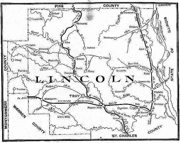
Map from The State of Missouri, 1904.
"Lincoln County"
from the
The State of Missouri, an Autobiography
by
Walter Williams
published by
E.W. Stephens, Columbia, Missouri, 1904
pp. 428-429
Edited for
M.T. Davis, F.J. Moss, B.H. Bonfoey, W.H. Marshall, J.H. Hawthorne, J.O. Allison, L.F.
Parker, N.H. Gentry, D.P. Stroup,
The Missouri Commission to the Louisiana Purchase Exposition
Map from The State of Missouri, 1904.
Lincoln lies upon the west bank of the
Mississippi river, forty miles north of St. Louis. Leading commercial and industrial
activities are builded upon agriculture, live stock and horticulture. It is one of
Missouri's leading wheat producing counties and also produces corn to the extent of a
million or more dollars annually. Cattle, horses and mules and hogs are among
surplus products of every farm; Buchanan College, at Troy, county seat, is a felt
influence; and a distinguishing feature upon the east side of the county is that of the
club house, several of which have been erected. County acreage is 382,720, equal to
598 square miles; improved farms embrace 252,984 acres of plow land. There are 2,763
farms in average size, 92.9 acres. Valued at $7,726,050.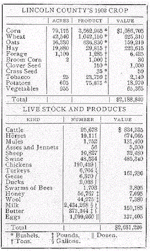
POPULATION: -- Estimated one-sixth German and German descent, mainly found in the south end of the county. White, 16,621; colored, 1,731; American born, 17,865; foreign born, 667; total, 18,352. Farm homes owned, 1,982; rented, 798; other homes owned, 630; rented, 503; total, 3,913.
FINANCE: -- County tax, $1.07; school tax up to $1; average, 38 cents; total assessed valuation, $5,445,454, one third of actual valuation; county debt, $184,000; no township debt.
COAL: -- Underlies ten thousand acres in vicinity of Hawk Point and Truxton. Fields have just been opened. Burlington railroad building switch. Heretofore local demands have been supplied; mineral, wagon hauled. Near Silex are vast deposits of white sand, suitable for glass manufacture. Portland cement materials are found in abundance near Elsberry. Neither sand nor stone is utilized.
LAND: -- Beginning on the east with the strip of bottom land bounded by limestone cliffs traced by the St. Louis, Keokuk & Northwestern railroad, the land therein is of two classes: upper, protected; and lower, unprotected. Land levee-protected in north end sells at $50 to $75 an acre, owing to improvements and location. Behind the levee, near Winfield, land brings $50 to $60. In southeast section of the strip, low bottom land, subject to overflow, sells as low as $5 or $10, up to $30. Low portions of the middle townships are of similar value. This land often adjoins higher bottom worth $50 and $60. Soil in the bottom varies from a very sandy loam to a heavy black bottom soil, all exceedingly rich. West of this strip defined by a line north and south through New Hope, Brussels and a point three miles east of Moscow, lies a strip of hill land rising in places one hundred and fifty feet above the valleys and worth $40, $50 or $60 an acre. Better portions are situated in the northern and southern one-thirds. Cuivre river and other stream valleys comprise choicest of the strip. Adjacent to this on the west for an average width of six miles is a rougher, less productive land, selling for $10 to $30, depending upon amount of creek bottom land embraced. West of this land gets gradually better, increasing in price to a range of $20 to $35. Land west of Troy brings as high as $40; that to the northward, $25, and Cuivre bottom land, $60, all being within a few miles of town. More desirable locations around Elsberry bring $40 to $60. In extreme northeast Lincoln county are a series of round-rising hills, three hundred to four hundred feet high, trending north and south, peculiarly valuable as fruit lands. Section is known as "Knob Lands." High rolling prairie occupies western one third of county. All west of line from Louisville to Millwood and southwardly through Linn's Mill, is of this character, except frequent bluffs are found along creeks. Prairie sells at $30 to $40 an acre, except in extreme southwest, where it can be had at $15 to $30. Best improvements are in northeast, southeast, west central and southwest sections. Two-thirds land grew oak, ash, hickory, walnut, maple, elm, sycamore, ash, linden and hackberry.
FLOUR: -- Is the leading manufactured product. Mills at Troy, Winfield, Moscow and Silex.
TRANSPORTATION: -- St. Louis, Keokuk & Northwestern, 21 miles roadbed; St. Louis & Hannibal, 33 miles; Burlington, 31 miles.
TURNPIKE ROADS: -- Twenty-three miles, connecting Elsberry to New Hope; Auburn to Silex to Olney. Twelve miles of rock and gravel road extends south and southwest from Troy.
BUCHANAN COLLEGE: -- At Troy; enrollment, 119; established 1894. Nonsectarian.
Winfield is location of sulphur spring; Whiteside location of lithia water spring; undeveloped. Club houses along sloughs and lakes fringing the Mississippi river, owned largely by St. Louis sportsmen.
TOWNS: -- Troy, Elsberry, Winfield, Silex, Moscow, Truston, Foley, Olney, Whiteside and New Hope; all supported by agriculture.
NEWSPAPERS: -- Troy Free-Press; Silex Index; Elsberry Democrat.
Return to USGW/MOGW Lincoln County, Missouri
History Page | Lincoln
County Maps | Home Page
NOTICE: In keeping with our policy of providing free genealogical information on the Internet, data may be freely used for personal research and by non-commercial entities, as long as this message remains on all copied material. These electronic pages may NOT be reproduced or redistributed in any format for profit or gain, nor presented by other organization or persons. Copying of the files within by non-commercial individuals and libraries is encouraged. Any other use, including publication, storage in a retrieval system, or transmission by electronic, mechanical, or other means requires the written approval of the file's author, Patricia SummersSmith.
You are visitor [an error occurred while processing this directive] since 4/30/99 when the page went online.